Hi, I'm Jessie Shapiro
Developer
Scientist
Analyst
applying geospatial technology to wildlife conservation and management.
View My WorkAbout Me
Hi, I'm Jessie Shapiro
I am a dedicated and professional GIS Developer based in Salt Lake City, UT, with over five years of experience. My work focuses on building robust geospatial databases and developing seamless integrations to power web applications. I am skilled at creating user-friendly interfaces for these applications, allowing users to interact intuitively with spatial data.
I am deeply passionate about applying GIS to fields like wildlife ecology and natural resource management. My expertise spans executing spatial analysis and managing geospatial data across various platforms, including ESRI’s ArcGIS, Google Cloud Platform, .NET Framework, and Umbraco CMS. With a versatile technical skill set, I adapt quickly to meet the needs of diverse projects and deliver impactful, data-driven solutions.

How I can help your next project
Database Management
I manage large-scale wildlife tracking and geospatial datasets using PostgreSQL/PostGIS. My work includes designing efficient schemas, optimizing spatial queries, and building systems that serve data directly to applications and spatial tools.
Web Development
I develop interactive, map-based web applications powered by custom APIs. These APIs serve data with support for user permissions and fast data delivery.
Spatial Analysis
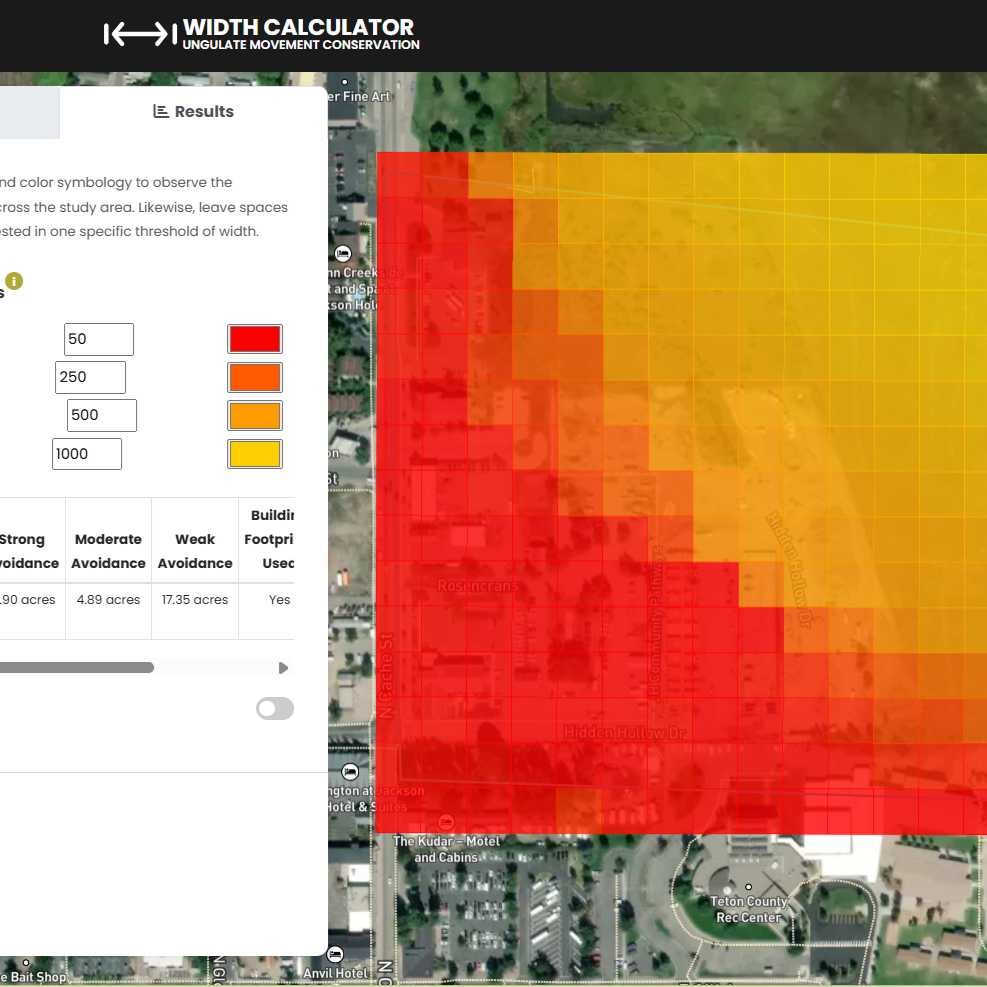
With a background in wildlife biology and GIS, I conduct advanced spatial analysis to support conservation decisions. I work in a variety of programming languages and develop web-based tools to analyze animal movement, land use, and habitat connectivity across complex landscapes.
Portfolio
Resume
Education
Master of Science in Geographic Information Science
University of Utah / August 2021
Bachelor of Science in Wildlife Biology
University of Montana / May 2015
Geographic Information Sciences and Technologies Certificate
University of Montana / July 2017
Experience
Research Scientist Associate
Univeristy of Wyoming / 2023 - Current
Develop and produce analytical workflows, technical assessments, interactive dashboards, and research to help manage and conserve big game habitat related to the wildlife management and conservation needs of USDA’s Working Lands for Wildlife Program and Wyoming Game and Fish Department. Additionaly provide analytical, data management, and research support for the Merkle Research Group, Wyoming Cooperative Fish and Wildlife Research Unit, Wyoming Migration Initiative, as well as state, federal, and NGO cooperators and partners.
Wildlife Migration GIS Specialist
Utah Division of Wildlife Resources / 2021 - 2023
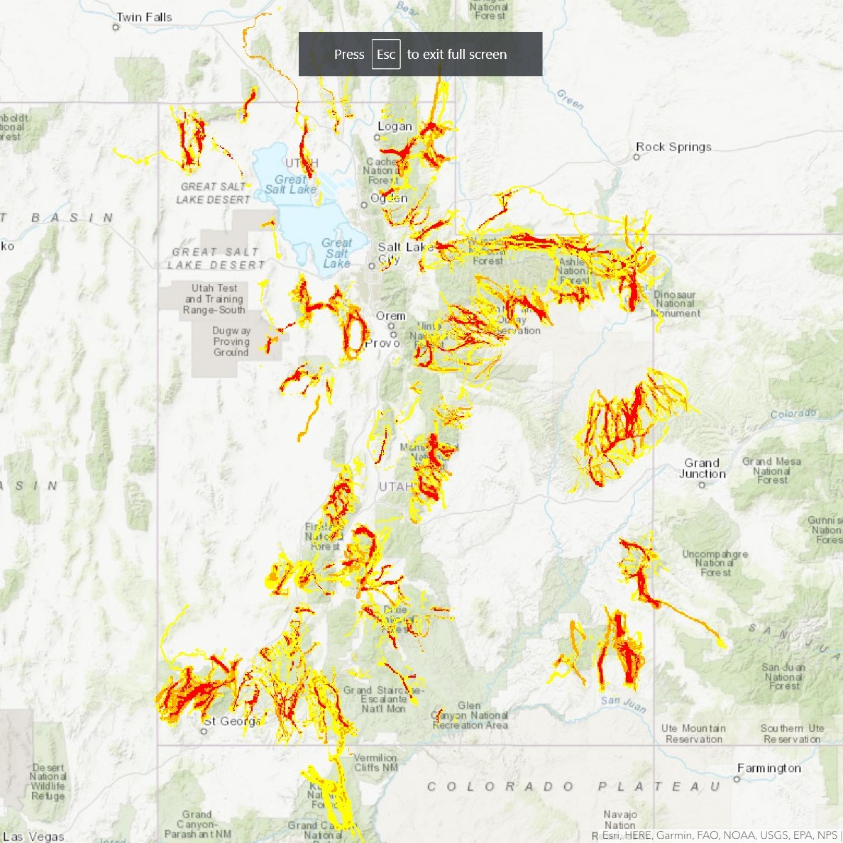
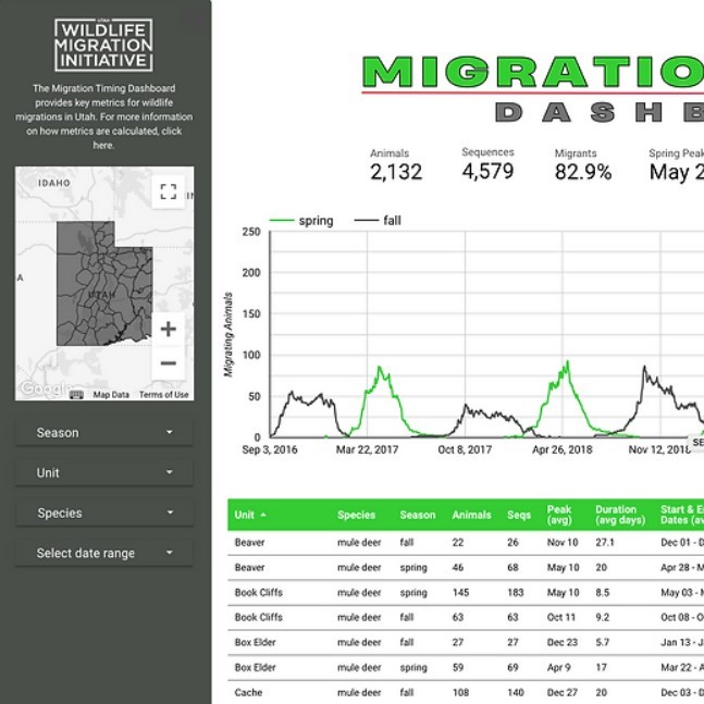
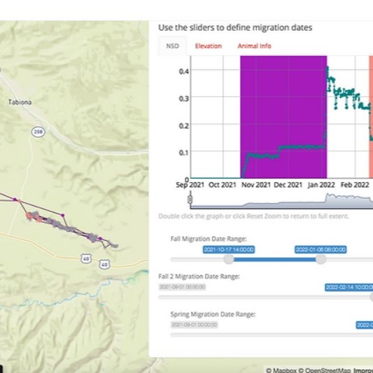
Support technical geospatial, data, research and application developments and products for the Wildlife Migration Initiative. Manage, analyze and visualize big data using cloud computing. Perform research analysis and complete various GIS and research-based projects using R statistical packages, ESRI products, and GCP. Build customized solutions for processing wildlife movements with R Shiny apps.
Wildlife Mgiration Technician
Utah Division of Wildlife Resources / 2019 - 2021
Maintain, edit and ensure quality control of spatial databases of wildlife locations for the State of Utah. Create programming scripts that detect and repair problems in the data. Assist in the migration of spatial SQL database to google cloud platform and development of web applications. Map migration corridors and home ranges using Brownian Bridge Movement Model for Utah using R scripts. Prepare GIS data requests for regional staff and partners.
Wildlife Technician
Utah National Guard/ 2019 - 2019
Developed relational spatial database for raptor and passerine survey. Develop web applications to streamline field data collection. Write and draft technical reports based on passerine demographics, raptor and vegetation surveys. Identify information from analyses that suggest developing patterns of problems or complaints from which general specific trends can be discerned, suggesting a need for further investigation.
Data Technician
University of Idaho/ 2018 - 2019
Transcribe nesting burrowing owl behaviors. Perform literature searches on North American passerines for comparative analysis on latitudinal pattern in clutch size. Responsible for data management and entry of passerine nest data in MS Access.
GIS Internship
City of West Jordan/ 2018 - 2019
Use a variety of geospatial tools to find, edit, digitize, geo-reference and display data using ESRI GIS software. Collaborate with management to see technical projects through from conception to completion.
Skills
- Databases:PostgreSQL, MS SQL Server, MS Access, BigQuery, Cloud SQL
- Programming:SQL, R, Python, JavaScript, HTML, CSS, C#, .NET
- Web Visualization:Mapbox GL JS, deck.gl, Open Layers, Leaflet, ArcGIS API for Javascript
- Software: ESRI ArcGIS (ArcGIS Pro, ArcGIS 9.3-10.7, ArcGIS Online, Survey123, Experience Builder, ArcServer, Field Maps), QGIS, R Studio, Google Cloud Platform (AI Notebooks, Cloud Functions, Cloud Run, GeoViz, Data Studio), Netlogo, Umbraco CMS
- Project Management:Trello, Asana, G Suite
Conferences
- WYTWS & COTWS Conference
Web Tools for Advanced Decision Making / March 2025 - WY TWS Conference
Web GIS / April 2024 - UTTWS & CCTWS Annual Conference
Mapping Wildlife Movement in QGIS Workshop / March 2023 - ESRI UC
Improving Wildlife Management with GIS / July 2022 - Utah Geographical Informational Council Annual Conference
Where's the Wildlife? / Oct 2021
In the News
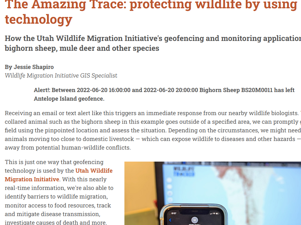
The Amazing Trace: protecting wildlife by using technology
How the Utah Wildlife Migration Initiative's geofencing and monitoring applications help bighorn sheep, mule deer and other species.
Read More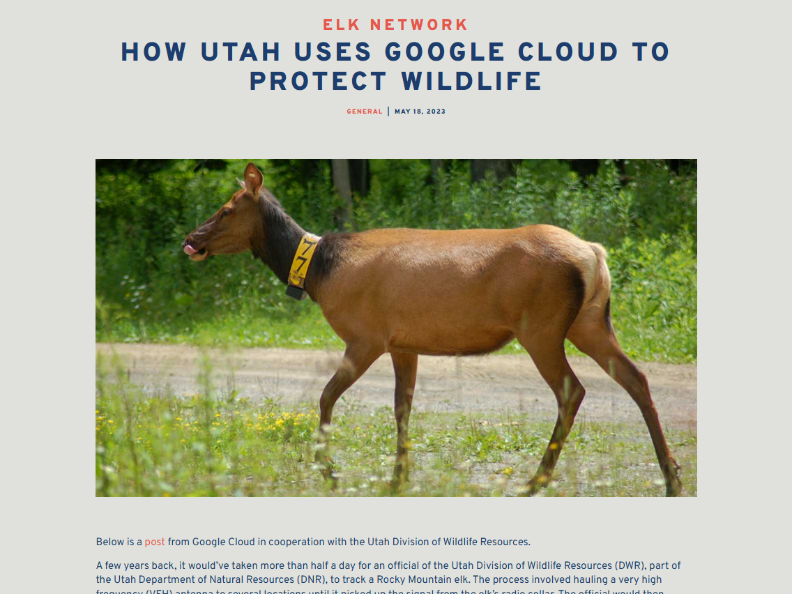
How Utah Uses Google Cloud to Protect Wildlife
“We are now able to know and understand our wildlife so much better. We understand patterns of migration, causes of death, and can obtain individual data points for thousands of animals. It has opened our eyes to how the animals are using the landscape, and what interventions we need for their safety and protection.”
Read More